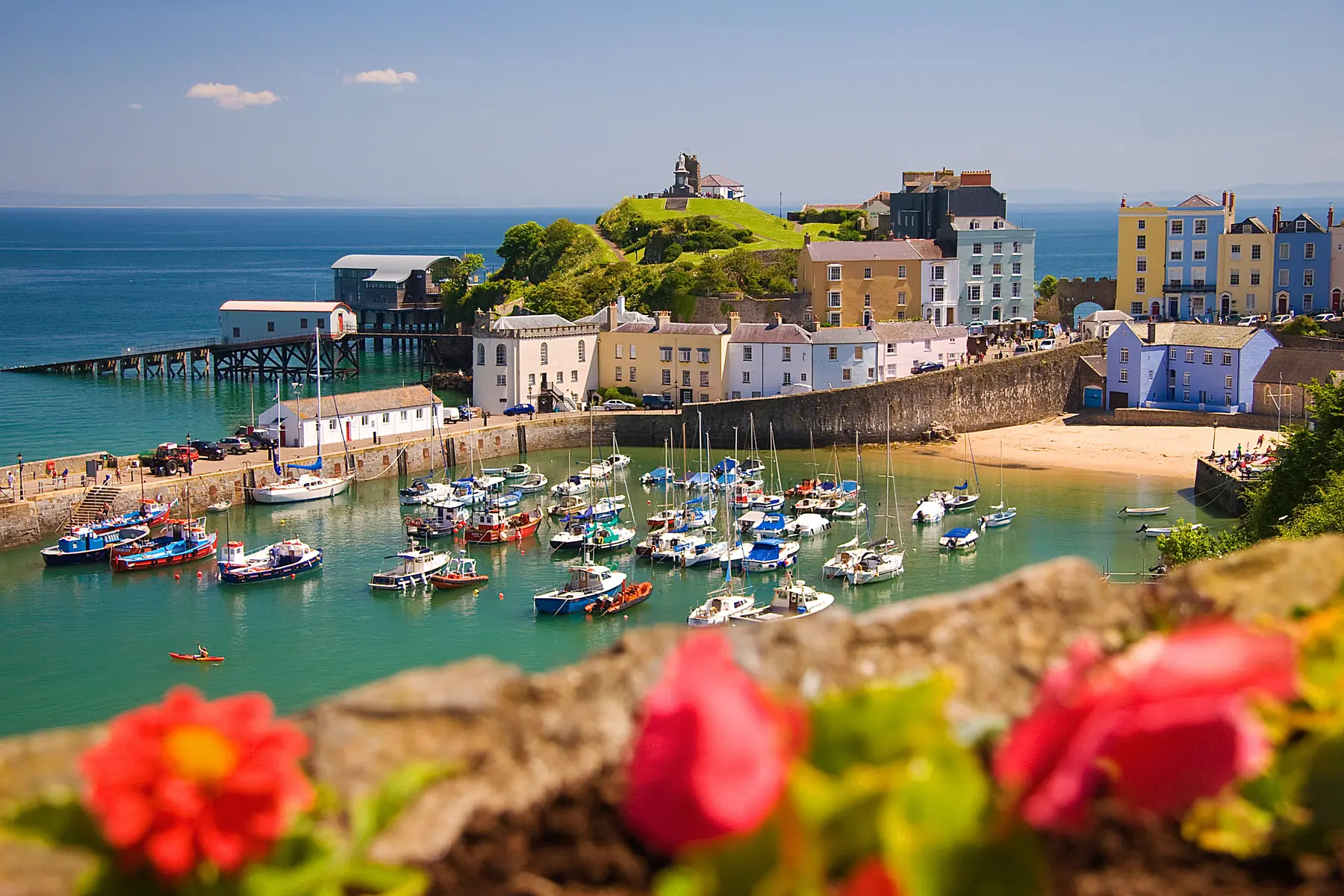
Very few towns in Britain have four sandy beaches within a few minutes’ walk of the centre. Tenby has them because it sits on a headland with the sea on three sides, and because the medieval walled town is at the top of a cliff with the sand at the bottom.
They are genuinely different from each other, and which one you use depends on the tide, the wind and what you are doing.
The big one. Two kilometres of sand running south-west from below the town towards Giltar Point, backed by dunes, with the Ritec valley behind and the golf links at Penally at the far end.
It is enormous at low tide and still large at high, it is the only one of the four with room for everything, and it is the beach for a proper beach day — space for cricket, kites, windbreaks and long walks. Lifeguards patrol in season.
There is a ramped access from the town at the Esplanade end, and the far end is quiet even in August because most people do not walk that far.
The interesting one. A curve of sand below Castle Hill, between the harbour and South Beach, with the Tenby lifeboat station on its slipway at one end and St Catherine’s Island offshore.
It has the best rock pools in the town, exposed at low tide around the island and the reefs, and it is the most sheltered of the three main beaches when the wind is in the north.
St Catherine’s Island is the thing. A tidal island crowned by a Victorian fort, built in the 1860s as part of the coastal defences against a French invasion that never came. You can walk out to it at low tide across the sand; it is cut off at high water, and people misjudge this every summer. The fort has opened to visitors at various times — check locally.
The photogenic one. A curve of sand below the town walls with the harbour at one end, the pastel houses stacked above it, and Goskar Rock — a lump of limestone standing on its own in the middle of the sand — which children climb on for the whole of a low tide.
It is the beach in every photograph of Tenby. It largely disappears at high water, which is worth knowing before you carry a family and a picnic down the steps.
The small one. A pocket of sand beside the harbour wall, sheltered, shallow and busy. It works for very young children and for anyone who wants to be five paces from an ice cream, and it goes under at high tide.
A full beach day: South Beach, for space and lifeguards.
Rock pools: Castle Beach at low tide.
The photograph: North Beach, with Goskar Rock and the town above.
Toddlers: Harbour Beach, or the sheltered end of Castle Beach.
A walk: South Beach to Giltar Point and back, about two hours.
Shelter from a north wind: Castle and South. From a southerly: North.
More important here than almost anywhere. Tenby has a large tidal range, and the four beaches behave completely differently across it.
At low water they effectively join into one enormous stretch of sand, St Catherine’s Island is walkable, the rock pools appear and Goskar Rock stands well clear.
At high water North Beach and Harbour Beach largely vanish, Castle Beach shrinks to a strip, and the island is cut off.
Get a tide table on the first day. Every shop in Tenby sells one and it will improve the week more than any other single thing.
Lifeguards patrol South Beach and, in season, others — swim between the red and yellow flags.
St Catherine’s Island cuts off fast. Note the time of high water before you cross.
Rip currents are less of a problem here than on the Atlantic coast, because Tenby faces east into Carmarthen Bay and is sheltered from the prevailing south-westerlies. It is still the sea.
The steps from the town down to North Beach and Castle Beach are steep. There is a ramp at South Beach and a lift near the harbour.
Seasonal restrictions apply on the main beaches, typically from May to the end of September, with North and Castle beaches usually restricted and parts of South Beach open. The signs at the top of each beach are the current authority, and outside the season the whole lot is open.
Saundersfoot, four kilometres north — a village beach with a harbour, shops and lifeguards.
Coppet Hall and Wiseman’s Bridge, on the same stretch, reached through the old coal tramway tunnels.
Amroth, seven kilometres north-east — a long beach at the start of the Pembrokeshire Coast Path, with the remains of a submerged forest visible at very low tides.
Manorbier, seven kilometres south-west — sandy, with rock pools and a Norman castle above it.
Skrinkle Haven and Church Doors, nine kilometres south-west — two small coves reached by a steep flight of steps, with a natural arch between them and among the most photographed beaches in Wales.
Lydstep Haven and Freshwater East complete the run.
Cars are banned from the historic centre in summer. Park at the top of the town and walk down; there is a park and ride in season.
Facilities. South Beach and North Beach have toilets and food nearby; all four are minutes from the town.
Deckchairs and windbreaks are hired on South Beach in season.
Sea temperature peaks in late August and September, and Carmarthen Bay is warmer than the Atlantic side of Pembrokeshire.
Tenby’s sheltered position makes it better for beginners than the Atlantic coast. Paddleboarding and kayaking operate from the harbour and South Beach, and the sound between the town and Caldey is calm enough for it in most conditions. Surfing is limited here — for waves you go west to Freshwater West or Newgale — but bodyboarding on South Beach works on a decent swell.
Sea fishing from the harbour is a Tenby institution: short mackerel trips run through the summer, they are cheap, and they almost always catch something.
Sea temperature peaks in late August and September, and Carmarthen Bay is a degree or two warmer than the west-facing Pembrokeshire coast — which is why the Victorians came here to bathe rather than to St Davids.
Worth knowing before you carry a family and a windbreak. Tenby is a walled town on top of a cliff, and the beaches are at the bottom.
South Beach has the gentlest access, with a ramped route from the Esplanade — this is the one to use with a pushchair or anyone who does not want steps.
North Beach is reached by steps from the town or from Croft, and there are a lot of them.
Castle Beach is down steps from Castle Hill or round from the harbour.
Harbour Beach is at harbour level and the easiest of the lot.
There is a lift near the harbour, and in summer a land train runs along the seafront. Cars are banned from the historic centre from around Easter to the end of October, so plan on parking at the top of the town and walking down.
South Beach for space and a full day; Castle Beach for rock pools and shelter; North Beach for the view.
At low tide, across Castle Beach. It is cut off at high water — check the tide table.
All four are sand, and at low tide they effectively join into one very large beach.
With seasonal restrictions from around May to the end of September on the main beaches. Check the signs; outside that season all are open.
Yes, on South Beach and others in season. Swim between the flags.